Plas Coch Roundabout could become a “squareabout” as wide consultation on new ‘active travel’ routes launched
Transport for Wales and Wrexham Council say they are looking to ‘progress’ work on one of four routes in the city for improvements to walking and cycling, and will be looking for your views.
Documents being circulated note four areas of feedback, with three initial routes detailed with ‘early ideas’:
- A525 Kingsmills Road (including links to the town centre) between its junctions with Kings Close and Bennion Road as well as onwards links towards the town centre via Bennions Road, Salisbury Road, Salop Road and St Giles Way.
- A534 Holt Road and Borras Road between the Cefn Road junction (the Greyhound Inn) and the A5152 junction, as well as onwards links to the town centre via Holt Street and St Georges Crescent, we have also looked at Borras Road
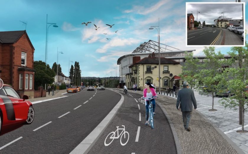
- A5152 Chester Road, with initial proposals looking at the section between its junctions with Glyndwr Road and Westminster Drive
Wrexham Council and Transport for Wales commit to a delivery timeline, subject to funding, “Based on the feedback we receive and taking account of other factors we envisage selecting one of these three routes to progress first and, subject to funding deliver, later in 2023/24. The other routes would then progress at a later date”, adding “Subject to funding we aim to be able to deliver initial improvements and begin phased construction later in 2023 and into 2024.”
A further route being looked at is the A541 Mold Road and Regent Street between the Plas Coch roundabout and the junction of Regent Street and Hope Street, including the A541 Mold Road, A5152 Regent Street, A5152 Bradley Road and A541 Central Road.

Kingsmills Road could see segregated cycle lanes on both sides of the road, separated from the footway with a kerb. They would be one way and cyclists would go in the same direction as the traffic. The documents state, “To make space for the active travel route we would need to narrow the traffic lane. Widths would vary but would be a minimum of 6m – 6.2m, with dimensions to be considered further at the next stage.” There would be a range of ‘improved crossings’ – Parallel crossings (like zebra crossings but with extra space for cyclists) and Toucan crossings (push button crossings which cyclists can use too). ”
Towards Salop Road and the city centre it adds, “A new shared use path between Bennion Road and St Giles Way, on the Lidl side. This would require widening out the footway and narrowing the road slightly. It might mean taking out the right hand turn lane into Bennion Road – this is something we will analyse further.”

Similar changes are proposed from Rhosnesni Lane roundabout / Greyhound Inn roundabout west into the city centre, with narrowing of roads to allow new crossings and bike lanes proposed. The plans extend into Holt St by Lambpit St, with more ‘speed cushions’ on the roadway to slow cars.
The ‘ideas’ for Chester Road start at the Garden Village shops and again end around the Lampbit St city centre location.
North of the Four Dogs pub would see a “New shared use path on the east side of Chester Road all the way to Box Lane. This would be around 3.5m wide. It would mean narrowing the road down to 6m – 6.2m”, with an ‘upgraded’ crossing by the shops.
To the south the raised separate route would be maintained, “Improve the existing off-road route by widening it out to provide more space for cyclists. Also separate pedestrians and cyclists with a green strip.”
The Mold Road area does not appear to specifically interact with the ‘Gateway’ plan but will provide ‘better links’. Similarly in what points at a wider lack of joined up thinking, the consultation notes of the south end of Chester Road would be “… difficult to narrow the road to make space for pedestrians and cyclists. Instead, we are looking at other options for a route slightly away from the main road, perhaps through Nine Acres playing fields and/or the Groves site, subject to future plans for that site.” At no point at previous discussions on the Groves or Nine Acre we have observed had it been mentioned they would be useful for future active travel routes – and thankfully there won’t be a school blocking a suggested red line route on the Nine Acre.
The Chester Road south of Powell Road would see a 20mph limit, ‘speed cushions’ to slow traffic and new and improved road crossings. The underpass under Powell Road would be ‘improved’ if all plans came to fruition.
All of the above help take cycle traffic from and to the city centre, however there does not appear to be any mention of extra bike storage space for people once they arrive.
The changes being looked at around Mold Road are described as, “…a range of different ways that the road could be redesigned to make it easier to walk and cycle between Wrexham City Centre and key destinations like Wrexham General Station, Glyndŵr University, Wrexham Maelor Hospital, The Racecourse Ground and other employment and residential areas. This includes consideration of relatively small-scale changes that would make things easier for pedestrians and cyclists (like dropped kerbs and continuous crossings across side roads) through to bolder ideas which would significantly change the way the road is used and how it looks and feels (like suggestions for one-way sections of street or shared spaces where pedestrians and cyclists have more priority). ”
It is reiterated the proposals are ‘early stage and no firm decisions have been made’, with two options being created, the first being similar to the above – with segregated cycleways and wider footpaths.
There would still be a ‘full reconfiguration of Plas Coch Roundabout to provide direct crossing facilities’ and Regent Street to operate as a one-way street westbound only, “making space for shared level street”.
The second is much larger plans, described as ‘bolder’, which would see “the Plas Coch Roundabout would be completely redesigned”, detailed as a ‘squareabout’, providing direct pedestrian and cycle movements.
A new pedestrian and cycle rail bridge would be built over the railway, and the current circulatory system by the Central Retail Park changed from one-way to two-way
Large changes to the east would also take place, “…Regent Street would be closed to through traffic between King Street and Hill Street and this area would be redesigned as a shared surface street. Also, the Bradley Road /Central Road/Regent Street circulatory system would change from one-way to two-way operation”
Detailed plans will be prepared ‘late’ 2022 – with the public engagement ending in December 2022.

More details on the consultation are set to be circulated this week, or you can speak with Transport for Wales – or your local councillor – for more information in the meantime!
Spotted something? Got a story? Email [email protected]