New Apple iOS6 Maps – Road Reappears After 140 Years
Wrexham.com readers with Apple devices such as iPads and iPhones could update them to the new ‘iOS6’. This promises a raft of improvements, but for smartphone users who use them as sat navs or mapping tools it could be a downgrade.
We have discovered a road that was not on maps in the 1870’s has somehow made it back to Apples maps in 2012!
Previously the devices used Google Maps, which by its name was mapping software by Google. Now, Apple themselves have created a map based software programme to try and take the users away from Google to Apples own services.
Nationally there has been problems reported, with Manchester United being located in Sale at a youth team ground.
Locally we have taken a look and think that Google Maps is still the leader…

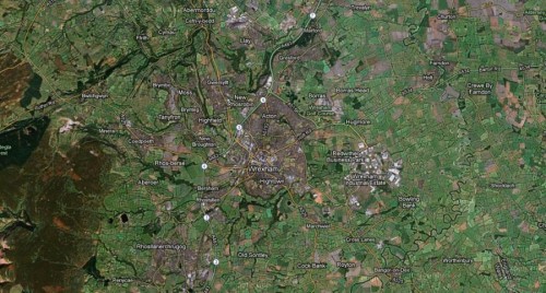
Apple’s take on the industrial estate link road – no road at all.

Google has one stretch of the new road on its maps.
Residents of Crewe are currently miffed as Crewe is being described as ‘Wrexham Crewe’ on the current version of the Apple Maps.

The location of Saith Seren / Seven Stars is a little out on Apple maps.

Littlewoods is apparently on Regent Street, along with several other incorrect shops.
Around Henblas St there is a ‘Guildhall Street’ which is no longer in existence, along side dots for Ethel Austin and Kwik Save on Chester St – which are no longer there. Likewise Wrexham.com fave, The Anise is now marked as being half way down Smithfield Road rather than opposite Eagles Meadow.
We have started this thread on our forums for you to point out what you have spotted, or if you see any oddities on either map! Click here to join in…
ADDITION – Road not on 1870’s maps appears in 2012 :
Guildhall Street as it appears on iOS6 Maps for iPad / iPhones:

In the hunt for ‘Guildhall Street’ we have checked a few records and have discovered that Henblas Street curved around to Kenrick St whereas Henblas St went straight through where the TJ Hughes is/was.
After that Henblas St was narrowed as per the picture above, and Kenrick Street disappears totally…as does Guildhall Street!

In Alistair Williams ‘encyclopedia of Wrexham’ he refers to Guildhall Street, which went past the old Guildhall – the grammar school on the above photo – and was once called Bottle Street. However by Guildhall street is NOT on the 1872 map we are looking at, but is for some reason on the 2012 Apple maps.
We have started this thread on our forums for you to point out what you have spotted, or if you see any oddities on either map! Click here to join in…
Spotted something? Got a story? Email [email protected]