‘Weather Bomb’ Warning For Next Few Days
Weather warnings are in place over the next few days as a period of bad weather is due to hit the UK, Wrexham included.
The ‘weather bomb’ term is not just a sensationalised word to make this sound grim, but another way of saying explosive cyclogenesis and is an actual term used. The conditions need to be a rapid change in pressure in a 24 hour period, which is occurring to the West of us.
This evening will see wind speeds pick up, with tomorrow being very windy with gales due to hit the area. Some forecasts are predicting thunder and hail, and falling as snow over higher ground.
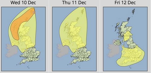
The Met Office has issued a yellow weather warning saying: “Very strong winds are likely to affect northern and central parts of the UK from Tuesday night until early Thursday as a very deep low pressure system moves slowly eastwards between Scotland and Iceland.
“A period of severe gales is expected over the highlighted area as well as the potential for storm force winds over western and northern parts of Scotland.
Gusts of 60-70 mph can be expected within the warning area, with 70-80 mph in western and northwestern exposures. The strongest winds will slowly ease on Thursday morning.”
The areas affected on the warning are:
The Met Office go on to say: “The public should be aware of the risk of disruption to travel and perhaps power supplies.”
As always if you have further information to how this develops or affects you, or have information that could help others please get in touch via [email protected] , Facebook message or tweet / DM us @wrexham !
Spotted something? Got a story? Email [email protected]